This web mapping app shows you the last-known parish for all 1,795 emigrants whose origin is confirmed, about a third of the nearly 5,700 emigrants who left England (and a few other places) for New England between 1620 and 1640. The emigrant information is based on The Great Migration Directory by Robert Charles Anderson.
The web mapping app gives you a map view of parishes and a list view of emigrants. The app opens in map view, and includes a set of options and tools for the map and access to the list view.
The parish map is based on digital boundaries of pre-1851 ecclesiastical parishes created by Burton, Westwood, and Carter at the Department of Geography of the University of Portsmouth, England. Some parishes that were subdivided by that digital map were recombined back into their 17th-century boundaries, but the focus of the edits was on the origin parishes and those nearby, so not all subdivided parishes were recombined. Also, long estuaries were removed by assigning portions of the watercourse to the adjacent parishes. The county boundaries were created from the resulting parish boundaries.
How to Use the Map View
The initial map view shows you the counties in England and Wales, and a few towns in Holland and Ireland.
Use the tools at the left of the screen to navigate the map:
- Get info on a parish
- Turn the legend on or off
- Zoom to the whole map
- Zoom into a portion of the map (larger scale)
- Zoom out from the current portion of the map (smaller scale)
- Pan to a new portion of the map at the same scale
Note that it takes a moment to redraw the map when you use the tools.
As you use the map, you can close info windows by clicking the X at the top right corner of the window. You can also use the Legend button to close all open windows at the same time.
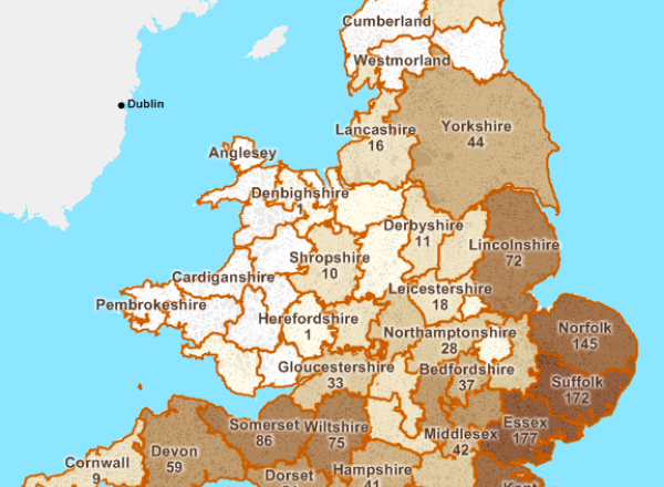
The counties are colored based on the number of emigrants. Emigrants from outside England are shown with a scaled symbol for town. The label for a county shows its name and number of emigrants (if any), and is visible if there is enough room to show it.
As you zoom into the map, at about the scale of the largest county (Yorkshire), the map changes to show the parishes, which are variably colored based on the numbers of emigrants. Labels appear as you zoom in farther.
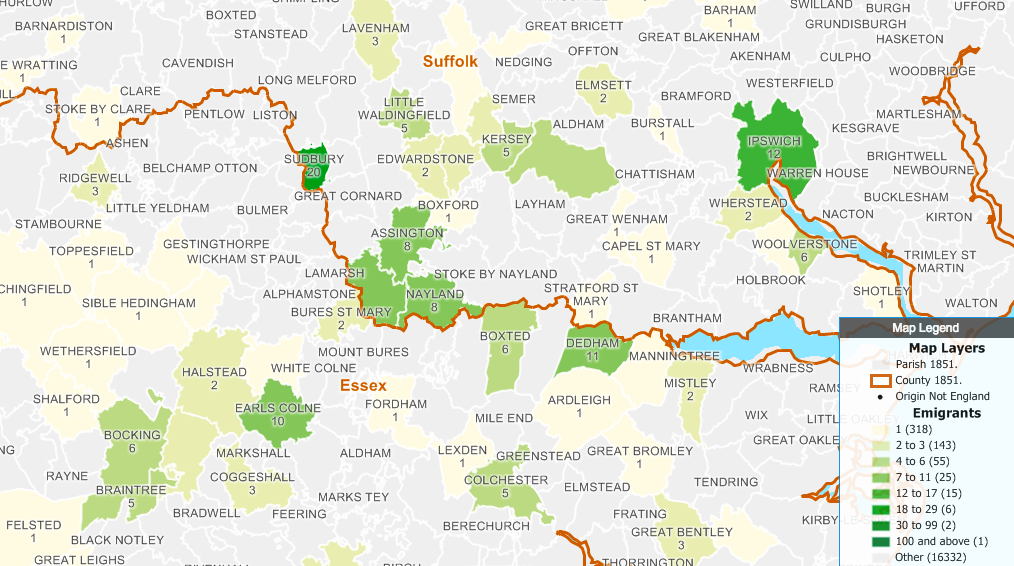
Grey parishes have no emigrants. In all, there are almost 17,000 parishes.
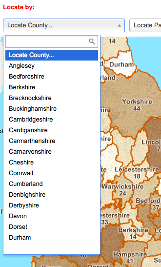
The County drop-down list contains all the counties. The Parish drop-down list only contains the 564 parishes of origin, though you can search either for a chapel/town or the parish that it is in, for those few emigrants with a sub-parish designation. The Person drop-down list, which is last name first, shows the New England town for those whose name is not unique. You can start typing any part of the name into the search box; for example, typing “inth” will take you right to “Winthrop John.”
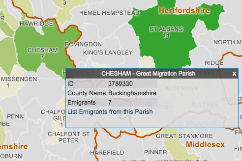
To see which emigrants are from a parish, select the Info tool, then click on a parish on the map. An info window will pop up with information about the parish. Click "List Emigrants from this Parish" to view the full list of names.
How to Use the List View
When you click "List Emigrants from this Parish" in an info window, you will be brought to the list view. You can also access the list view by clicking "Show List" at the top right corner of the map view. Once you are in the list view, you can click "List All People" at the top of the screen to access the full list of emigrants.
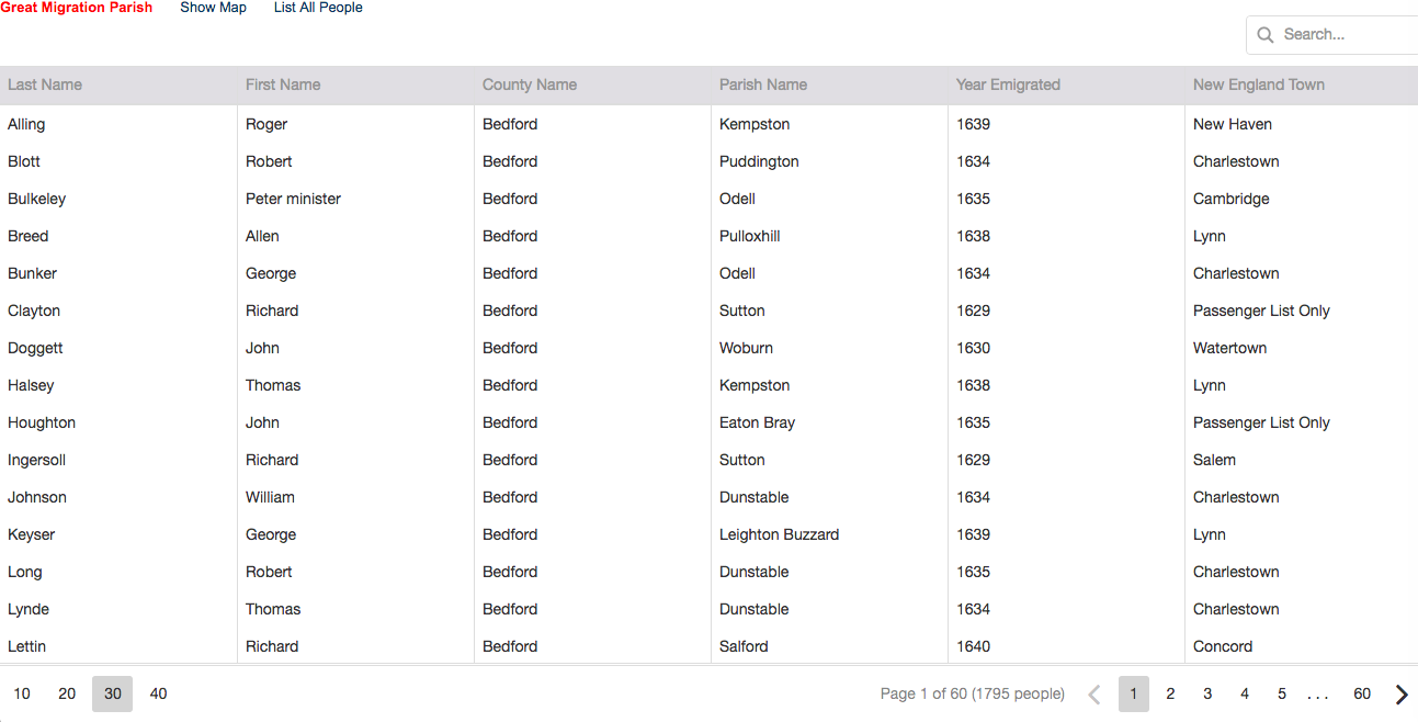
Use the controls at the bottom of the list to change how the list is displayed. At the bottom left, choose 10, 20, 30, or 40 to change how many names are displayed on each screen. You may need to scroll to see all of the names on each screen. At the bottom right, use the left and right arrow buttons to navigate between pages of results, or choose a number between the arrows to jump to that page.
Click on an entry in the list to return to the map view and zoom to that person's parish. You can also return to the map view by clicking "Show Map" at the top of the screen.
The columns in the list are:
- Last Name
- First Name (includes "Minister" for the 93 emigrants who were ministers, and "of [New England Town]" for the 75 people whose name is not unique)
- County Name (includes "Holland" or "Ireland" for non-English parish emigrants)
- Parish Name (includes "Unknown" for the 35 people for whom only the county is known; town name for Ireland and Holland except for the 3 people for whom only the country is known)
- Year Emigrated
- New England Town (includes "Passenger List Only" for the 121 emigrants who did not stay)
You can search the currently displayed list by typing in the search box at the top right of the screen:
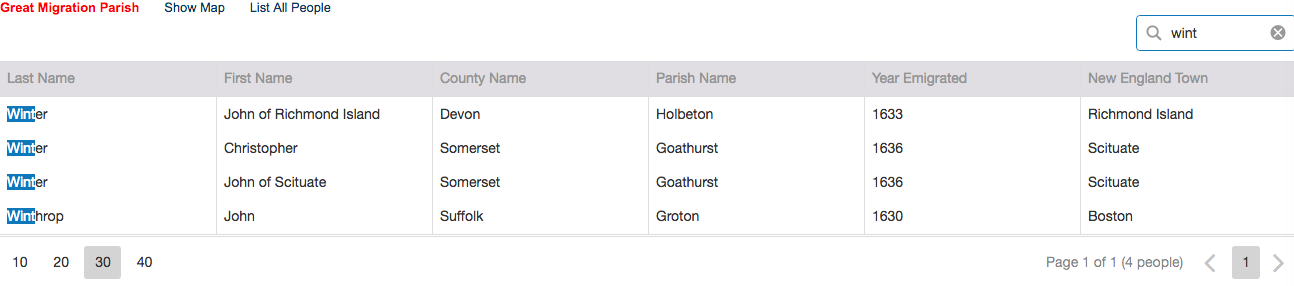
Start typing a set of letters to view a list of names with matching letters. The matches will become highlighted as you type. Note that matches can occur in any column of the list. Click the X in the search box to clear the search.
You should now be ready to navigate the map and the list to find individual emigrants and see the pattern of emigration.
About the Authors
Robert Charles Anderson, FASG, is the Director of The Great Migration Study Project at the New England Historic Genealogical Society and the author of many publications, including The Great Migration Directory, the source of the emigrant information.
Giovanni Flammia, PhD, is Director of Web Development at Caliper Corporation. He provided the software support for the web mapping app, which is hosted on a server courtesy of Caliper Corporation.
Peter H. Van Demark, GISP, is Principal GIS Specialist at Caliper Corporation and a Life Member of the New England Historic Genealogical Society. With his wife Kathleen, Peter has been on all four of the Great Migration tours led by Robert Charles Anderson. It was on the third, sailing to England on the Queen Mary II, that the idea for the web mapping app began to take shape. Peter edited the parish boundaries and did the data preparation to meet the needs of this web mapping app.